Mt Hood National Forest Campfire Ban

mt hood single track mt bikingAugust 5, 2020: The USFS has announced a campfire ban on the Mt Hood National Forest. The ban applies to all camping – developed or not – in and around the 44 Trails zone. The trails remain open and rideable!

Campfires prohibited on Mt. Hood National Forest

Due to dry and hot conditions, campfires are now prohibited across the Mt. Hood National Forest, including in developed campgrounds.

All campfires, charcoal or briquette fires, pellet fires, or any other open fires are prohibited under a Forest Order.  Portable cooking stoves and lanterns using liquefied or bottled fuel are still allowed as they can be instantly switched off.

July was much drier than average, and August and September are predicted to have higher than average temperatures.  These conditions will continue to increase the risk of wildfire- especially on the east side of the forest.  At the same time, Mt. Hood is experiencing extremely high visitation, increasing the number of preventable fires.

Forest Service crews extinguished over 100 abandoned campfires across the Mt. Hood National Forest in July.  With the current dry, hot conditions any wildfire start poses a greater threat to firefighter safety, public safety, and personal property.  This year every preventable fire also increases our firefighters’ risk of exposure to the COVID-19 virus, which could impact our ability to respond to fires as the season continues.

“We know campfires are a big part of camping, but this year especially we all need to do our part to prevent wildfires,” said Dirk Shupe, Fire Management Staff Officer for the Mt. Hood National Forest.  “Fires caused by abandoned or escaped campfires create unnecessary risk for firefighters, our communities, and the forest.”

More forest information and the full text of the Forest Order is on the Mt. Hood National Forest website at:https://www.fs.usda.gov/main/mthood/fire.  The forest also shares recreation, fire, and safety updates on its Facebook and Twitter accounts at: @MtHoodNF.

For more information about the local and regional fire outlook visit: https://gacc.nifc.gov/nwcc/predict/outlook.aspx

Fire Closure Still in Place

It looks like the USFS is going to maintain its existing fire closure for the foreseeable future. Sorry, but the 44 Trails area will be closed for the Labor Day holiday weekend.

The wet and cooler weather has definitely aided in the management and suppression of the Government Flats fire that lead to the road and trail closures but there is still work to be done and fire hazard in the area. The burn has been spotty in areas, which makes mop up efforts a bit more difficult to monitor assess.

What we need is a big multi-day rain cycle. In the mean time, check out rides on Gunsight ridge and the Boulder Lake zone. You can keep tabs on the fire updates at www.inciweb.org/incident/3662/

Latest Fire Closure Update for 44 Trails

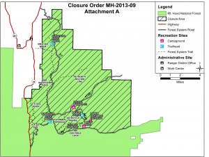
USFS 44 Trails closure map

USFS 44 Trails closure map

West winds have cleared the smoke from the Hood River Valley, but the 44 Trails area is still effected by closures. As far as we know, the trails themselves have not been consumed by fire, but there will be active fire suppression efforts in the area and the threat of fire growth, so the USFS is going to keep the zone east and north of the 44 road off limits for a while.

Here’s the latest:

The Mt. Hood National Forest has announced the following closures:

The following campgrounds are closed: Knebal Springs, Lower Eight Mile Crossing, Eight Mile, and Gibson Prairie. Five Mile Lookout is also closed.

The following major trails are closed:

  • Surveyors Ridge # 688 both south and north trailheads
  • Eightmile Loop #496
  • Knebal Springs # 474
  • Bottle Prairie #455
  • North-South #451
  • Oak Ridge #688A
  • Dog River #675
  • Zig Zag #678

Forest Roads 17, 1720, 4430 and all their associated spur roads are closed along with and all other National Forest System Roads and minor trails within the closure area depicted on a map posted on InciWeb.org at http://inciweb.org/incident/maps/3662/

Fire Closure Update for 44 Trails Area

fire map 8/23 update

fire map 8/22 update

Growth of the Government Flats Fire Complex on August 21 is leading to more road/area closures related to the 44 Trails area. Although the decision is not yet final, today’s morning meeting proposes the closure of the FR 44 east of Highway 35 and north to the forest boundary. This closure will effectively close access Knebal Springs, 8-Mile and Surveyors.

The area is experiencing heavy ash and smoke as well (on 8/22), so really, it’s not a good place to try and recreate, regardless of the closure. West winds will help blow smoke out of the area this weekend and should help reduce threat to the 44 Trails area.

The fire has not burned into the trails proper but the risk of it spreading in the area is high given any east wind events.

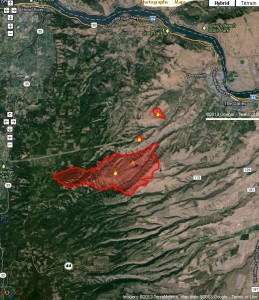
Here’s a map of the latest fire location. FR 44 runs east/west in the bottom of the image.

Get the latest fire closure information from the USFS news feed

or

the InciWeb.org fire information page